Підходи та обладнання для прискорення обробки даних агромоніторингу з БПЛА
Ринок послуг UAV regarding remote sensing has huge prospects for managing the crop, but it is still not developed enough due to non -working methodological approaches. The standard proposal for probing is formed as a nitrogen supply map, moisture, damage to harmful organisms, etc., which are provided by the company for three days.
in plant practice, the effectiveness of technological techniques depends on the timing of their execution, and therefore the efficiency and objectivity of the results. Both in cloud services on remote servers and directly in the field in the presence of powerful laptops, the cost of which is acceptable for most farms. Obviously, the problem is different, first of all, it is related to methodical issues.
Великі обсяги даних можуть обраховуватись як в хмарних сервісах на віддалених серверах, так і безпосередньо в польових умовах за наявності потужних ноутбуків, вартість яких прийнятна для більшості господарств. Вочевидь, проблема в іншому, передусім вона пов'язана саме із методичними питаннями.
It is not difficult to shoot and make a map - the geometric parameters of the objects are easily fixed, the problems begin in the measurements of spectral indicators, since they depend on many indicators and above all on the state of lighting and the angle of slope of the sensor. If in the shoot, in particular to create vegetative maps, these issues are not methodically resolved, the equipment is used mainly in the indication mode. The peculiarity of the indication regime is the identification of the fields characteristic of the fields on which land studies will be conducted, which will create appropriate maps. In this approach, given the dimensions of the fields, it will not be significantly accelerated, and without this mass industrial implementation is doubtful.
methodological approaches to correction by lighting
methodically solving this problem is possible in several ways, both borrowed from satellite technologies and inherent in UAVs. Satellite monitoring has been used since the 1970s, and the issue of obtaining reproduced data for changes in lighting has been processed at serious technical and organizational levels. If access to land objects, as in Western Europe and the United States, the example of weather stations created a network of stations that recorded the magnitude of sunlight and on the basis of this were corrected by lighting. If access was complicated or impossible in the territories of the USSR, useful optical patterns were used: deep -water reservoirs, objects with known parameters (roofs of buildings), asphalt roads, etc. Despite some successes, the problem was not finally resolved and experts had to take into account the possibility of "mosaics" on a map derived from pictures in different lighting, since there are certain problems with the presence and efficiency of natural patterns.
This approach can also be used for UAVs, which produces special diffusion panels of reflection. Diffusion (matte) panels, compared to glossy, have a stable and stable reflection regardless of the level of the device, light and geometry of viewing. Therefore, in the presence of the camera of the object with known and stable parameters, you can list the monitoring results, which is easy to implement for relatively small objects. For the field, this will be difficult for both financial and organizational reasons, as the panel should have significant dimensions for confident fixation from the UAV and be placed directly near the experimental objects. The execution of such panels in the stationary mode is impractical directly in the fields, as they require service, including removal For remote sensing
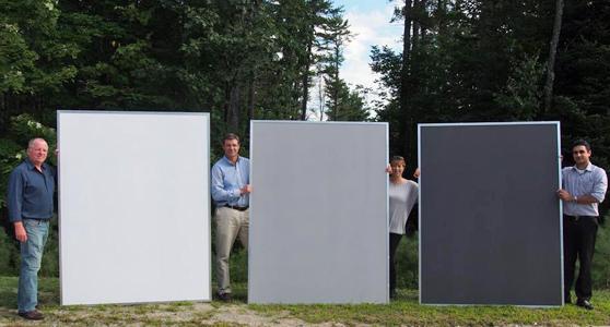
Дифузійні відбивні панелі (https://www.pro-lite.co.uk/File/reflectance_targets.php) для дистанційного зондування
therefore, this approach is acceptable for precision measurements, but is little acceptable for mass implementation in domestic industrial fields with an area of tens or hundreds of hectares.
= Alternative to ground -calibration is the use of a regular camera exponent, which in automatic mode is evaluated by the level of illumination of the object. The duration of the shooting (exposure time), the number of the diaphragm and other parameters are recorded and exiff the image file data. On the basis of this data, you can develop equations to take into account changes in lighting, but they will be individual for a specific brand of camera. This approach is easy to implement on ordinary cameras with one lens, and for professional cameras with several separate measuring channels, the optimal exposure period will be different and, accordingly, other solutions are required. || 108
Спектральні системи моніторингу для БПЛА із зенітним сенсором
because lighting calibration is mandatory for industrial solutions, quite logical and correct step in the development of spectral system of agricultural monitoring for UAVs. One of the first serial models in which this innovation was implemented was the Parrot Sequoia camera, which was positioned as a budget version of professional spectral equipment. This lightweight sensor can be installed on a mini UAV, has 4 spectral channels (NIR, Red Edge, R, G) to monitor and an additional RGB channel to facilitate the operator when choosing an object. The ability to distinguish is 13 cm/pixel at a height of 120 meters.
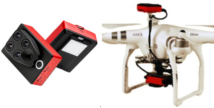
Parrot Sequoia camera has 4 spectral channels (Nir, Red Edge, R, G) for monitoring and additional RGB channel. And also the option of installing it on the copy.
= The closest analogue of Parrot Sequoia is the more costly Micasense Rededge-MX system, which has greater weight (180 grams) and extended opportunities for the ability to distinguish spectral composition-8 cm/pixel at a height of 120 meters. An additional blue channel makes the system more versatile. The advantage is also improved communication capabilities that have made it possible to expand the integration capabilities to UAV autopilot. || 121
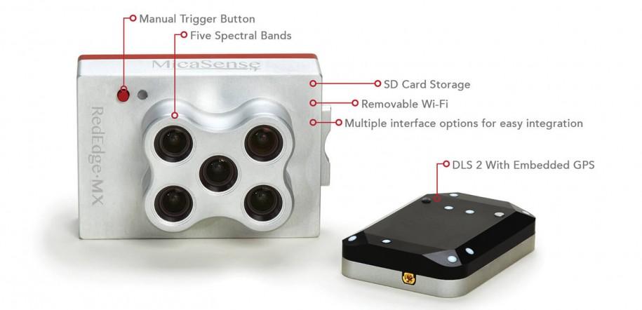
Система MicaSense RedEdge-MХ
= Now the additional anti-aircraft sensor has become a standard kit for UAV-based professional systems. An example is the complex on the base of the quadcopter Phantom 4 Multispectral. DJI has developed a whole line of various devices on the basis of Phantom 4 platform, such as geodetic needs with RTK system, as well as capable of providing a 10-cm and higher accuracy of the multi-inspest system for farmers.
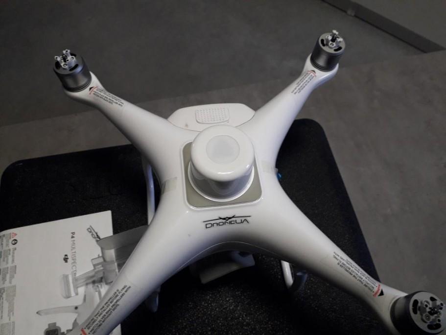
On top of the copter is a stationary anti -aircraft sensor.
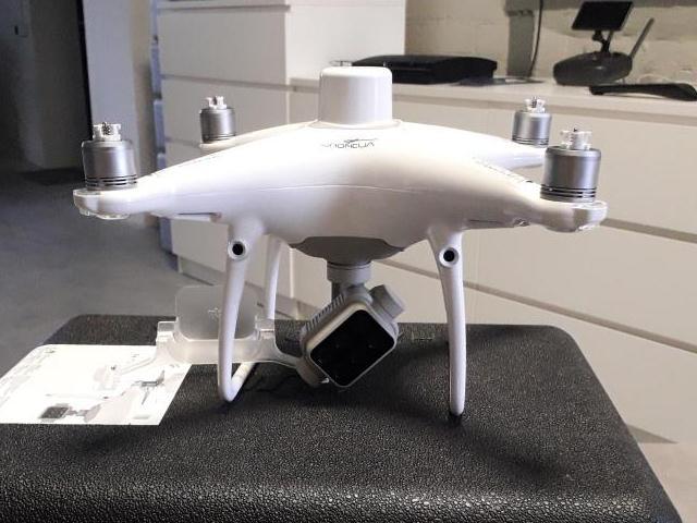
= But this is how the anti -aircraft sensor looks from the outside. The bottom sensor is mounted below. In general, the task of finding a configuration that is optimal for each user has no solution. With regard to computer equipment, which was the same problem regarding the needs of consumers, an open architecture was implemented when the motherboard can be added blocks of third -party developers and easily integrated them into the software environment.
Універсальність щодо платформи полегшує сервісне обслуговування та доступ до запасних частин, проте універсальність не сприяє індивідуальності. Загалом задача підібрати конфігурацію, оптимальну для кожного користувача, не має рішення. Стосовно комп’ютерного обладнання, для якого була така ж проблема стосовно потреб споживачів, було реалізовано відкриту архітектуру, коли на материнську плату можна додавати блоки сторонніх розробників і легко інтегрувати їх в програмне середовище.
similar solution was made for spectral equipment for UAV - modules from Kernel. In the development of the latter, experts sought not to develop the camera, but the optimal system for UAVs. In fact, the solution is a designer when the user himself is chosen by a phototosener, filter, lens, and more. In addition, Kernel is the first camera that supports Uavcan, "a light protocol designed to communicate with robotic applications through CAN tire." The CAN tire connects the readings of the flight controller with the nucleus.
= Today, the standard data package contains positioning for GPS, shooting time, air velocity, compass, gyroscope, accelerometer and level horizon. All the sensor data that the user has selected will be rigidly encoded to each captured image (Exif) to help in image processing.
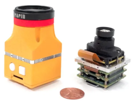
however, this is the case when individuality is not cheap, and the cost of each channel directly from the manufacturer is from $ 1000.
= ultimate
= Practically all professional systems are worth a lot, but they allow a lot to earn. Yes, the system installed on the platform is actually capable of inspecting areas of hundreds of hectares during one departure. Professional spectral systems also have features that we will look in more detail in the following Eplications=.
Пасічник Наталя Анатоліївна (n.pasichnyk@nubip.edu.ua)