The pupil of the aerial eye - we are equipping a drone to assess crops
An experienced agronomist can determine the problem areas of crops with high accuracy by the color of plants and, with some probability, interpret the reasons for their occurrence.
Now aerialdrones are capable of lifting a digital camera several hundreds of meters and thus become a common tool in agricultural production.
However, when choosing equipment, there is a question about the desired spectral range. For wheat, the optical range from an ordinary camera may be sufficient to determine the need fornitrogen nutrition, but for corn this is not enough.
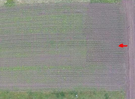
The picture shows a photo of the research station of NUBiP of Ukraine for the study of fertilizer application systems, and the dosage of fertilizers increases starting from the road. In the optical range, no significant difference in spectral parameters was detected at different values of nitrogen supply.
Based on the experience of space research, the infrared range is also suitable for determining the moisture of plants, monitoring diseases, detecting the foci of pests, etc. How do you get that extra range on a regular digital camera?
We use optical filters for ordinary cameras
The standard design of a digital camera involves the sequential use of an infrared filter, after which optical filters are located. If the infrared (hot mirror) filter is removed, the device will also capture infrared radiation, since optical light filters are somewhat transparent to it.
In some camera models, a protective infrared filter is applied to the lens, and replacing the lens turns the camera into infrared. As an example, the GoPro HERO4 action camera. The cost of such equipment on the Ukrainian market is about $150-220, which is quite affordable for the agricultural sector..
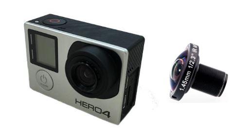
GoPro HERO4 action camera and a specialized lens for capturing infrared radiation
As in the case of an optical lens, when using an IR lens, three component colors will be captured, which were called pseudo-colors, consisting of different combinations of red and infrared components of the spectrum. In photos taken with an iR lens in jpeg format, the iR1, iR2 and iR3 channels will be perceived as red, green and blue respectively.
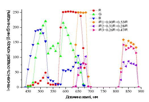
Dependence of the intensity of the spectral channels depending on the wavelength of the GoPro HERO4 camera with optical and IR lenses
Despite the presence of both infrared and red components in the recorded radiation, their direct value can be calculated using a simple proportion based on the experimental equations shown on the graph.
However, in practice it is possible to use the data obtained with an infrared lens directly without calculations. The resulting color image is called a pseudo-color image.
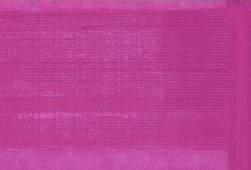
A photo of the same stationary experiment for corn crops in pseudo-color is already more suitable for identifying the state of nitrogen nutrition
For some crops, the infrared range is necessary. At the same time, other variants of the spectral composition for pseudo-colors are possible, depending on the composition of the light filters.
Available solutions in serial equipment
Such relatively simple solutions are already implemented in serial equipment. Since 2015, the production of compact "budget" sensors, available for small farms, has been started under the MAPIR brand. In 2015, a device was released under the name Survey1 that recorded blue and infrared channels. For the Survey2 sample released in 2016, 6 light filters were already available - RGB, NDVI Red + NIR, Near infrared + NIR, as well as separately red, blue and green. Starting in 2017, along with the appearance of the Survey3 device, deliveries of specialized light filters under the Kernel brand began, with an increased number of spectral channel options.
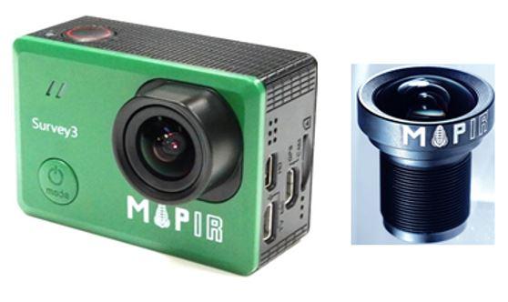
Survey3W interchangeable lens camera ([url="https://www.mapir.camera/pages/survey3-cameras"]https://www.mapir.camera/pages/survey3-cameras[/url])
As of 2018, the following combinations of spectral channels are available: RGB, Orange+Cyan+NIR, Red+Green+NIR, NIR+Green+Blue, Red-Edge, NIR. In fact, the cameras of the Survey series are built on the basis of a conventional optical range camera and can be upgraded "on the spot" according to the user's needs. Thanks to this user, the following vegetation indices are available: NDVI, GNDVI, OSAVI, TVI, CV, ENDVI and others. In addition, the nomenclature of light filters is constantly updated and new versions of vegetation indices become available.
In Ukraine, the cost of such equipment is about $900-1000, which is relatively inexpensive for professional equipment. Of course, it is possible to save the budget and replace the light filters on the camera yourself to identify problem areas in the field. But when using serial equipment, it is possible to effectively use both domestic and foreign consulting services for image analysis.
Today it is quite possible to get universal equipment suitable for crop management when determining the state of nutrition. We are certain that these digital technologies are currently acceptable in terms of the "price/functionality" ratio and can be effectively used even in small farms.
Beekeeper Natalya Anatoliivna ([email protected])