Sentera sensors for agricultural monitoring with UAVs
Crop management technologies are relevant for all farms - from small farms to huge agricultural holdings. Equipment is also being developed to meet the needs of such farms of different scales. The purpose of this article is to introduce readers to Sentera's specific spectral sensing equipment.
A feature of agricultural production in the countries of the post-Soviet space is the large dimensions of fields of several tens of hectares, which were organized under collective farms and state farms. In the countries of Western Europe and the USA, there is a large number of small farms, the fields of which are up to 10-15 hectares in size. There are quite a lot of such consumers, they have their own specifics, which creates a large niche in the market of aerial systems for monitoring, which both well-known tool developers and new startups seek to occupy.
Equipment requirements
The main requirements of such small farms:
- low cost of sensor equipment;
- possibility of using widespread cheap UAVs of the mini class as a platform;
- possibility of identifying problem areas directly during the flight, without the need to use cloud services.
Accordingly, the technical task for creating such sensor equipment can be formulated as minimizing dimensions, weight and cost. A typical solution for solving such problems is the development of highly specialized equipment, when everything that is not used directly for solving problems is removed. Among the more familiar to average computer consumers, an example of such equipment is single-board computers such as Rasberry Pi starting at $30.
Sensing equipment for UAVs from Sentera
Such an approach to spectral sensor equipment forUAVs was proposed by Sentera, a startup from Minnesota (USA), which promotes NDVI visualization technology on the market. which was named LiveNDVI. A miniature digital camera is integrated directly on the board, where an image is generated in NDVI format - a color picture of the distribution of this most common vegetation index.
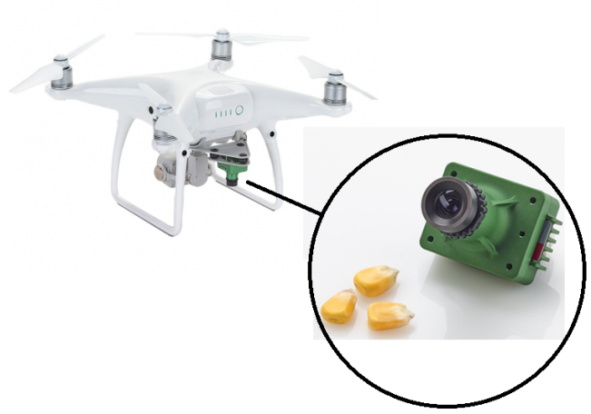
Single-lens NDVI or NDRE sensors from Sentera installed on the DJI Phantom 4 UAV
That is, for a small field, the farmer can immediately identify the places that should be paid attention to, because, in addition to the lack of nutrients or water, the problem may also be the nests of pests. Directly in the USA, such sensors are installed by the developer company on DJI Phantom 4 Pro V2.0 and Mavic UAVs, although there may be other models of aerial robots.
The multispectral version of the Double 4K sensor offers five spectral bands: blue, green, red, boundary red and NIR, i.e. the main channels for monitoring vegetation. Such image saving formats as JPEG, RAW, TIFF are available.
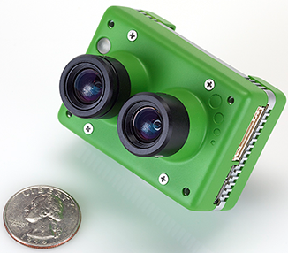
Sentera Double 4K Sensor (https://sentera.com/sensors/)
Due to small dimensions and weight, Sentera Double 4K sensors are positioned as compatible with any UAV of the mini class and above. It is possible to install sensors on common all-weather DJI Inspire 1 UAVs without using additional cables or a special suspension, which is necessary for most similar spectral complexes. The flight duration of 18 minutes inherent to the DJI Inspire 1 is quite sufficient for small fields.
For maximum unification, the developers took into account the most common form factors of filming equipment for standard UAVs. Thus, the Sentera Double 4K sensor can be easily mounted on the stand of the popular GoPro® HERO 4 action camera on the market.
A rigid mount, in addition to the positive points in terms of minimizing mass and installation cost, also has operational disadvantages related to the vibration of the UAV and its inclinations during wind gusts and maneuvering. If we talk about the videos of sweats, then this somewhat complicates the perception of information, however, for creating maps of the distribution of vegetation indices, it is a significant methodological problem. For such users, the company offers a special stabilized cardan suspension.
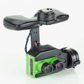
Sentera Double 4K sensor on a stabilizing gimbal for DJI Inspire 2 and Inspire 1 UAVs (Lock & Go technology)
For larger fields in the Sentera sensor line, the AGX710 Ag Precision Sensor is presented on the Ukrainian market.
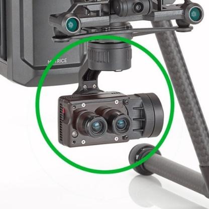
Sentera AGX710 sensor (https://smartdrones.ua/products/agx710)
The recommended carrier of such a sensor is the DJI Matrice 200 Series UAV, the flight duration of which is 38 minutes, thanks to which it is able to survey up to 65 hectares.
In addition to the sensor equipment, the company has also developed the appropriate Sentera FieldAgent software, designed for processing photography data. In general, the issue of creating digital maps based on photographs is already sufficiently well developed, there are many programs from different developers, such as:
- pix4d (https://www.pix4d.com/);
- Agisoft PhotoScan (https://www.agisoft.com/) is a paid software, but there is a free period of use and Russian localization is available.
There are also free services, but most of such software is focused on cloud services, which requires high-speed access to the Internet, which is not always convenient and cheap to implement in field conditions. Considering the specifics of agricultural production, Sentera FieldAgent software can work autonomously without Internet access and is able to generate shapefiles (.SHP) from the task directly for ground equipment.
Undoubtedly, Sentera solutions are interesting and have found their niche in the market of agricultural equipment, especially as an indicator tool for an agronomist. However, there are certain drawbacks when constructing maps of the distribution of vegetation indices, namely the lack of a system for automatically taking into account changes in illumination, which is very important in the measurement mode. Such uncorrected data require additional ground research, which complicates the automation of these processes, since for calibration it is necessary to have values from the entire possible range of values of vegetation indices in the field, and it is not a fact that it will be possible to find such a convenient area nearby.
And for the rest...
The market of agricultural services is developing rapidly, including the range of spectral sensor and related equipment for remote monitoring. Therefore, it is worth constantly monitoring the latest developments.
Today, there is already professional spectral equipment capable of taking into account changes in lighting at the expense of standard equipment. We will consider them in the following articles. Beekeeper Natalya Anatoliivna (статтях.