/ Agricultural equipment, equipment, inventory / Agricultural equipment, inventory / Systems of precision agriculture / GPS tractor navigator


Sell / buy
GPS tractor navigator, Ternopil region.
Price12,500 UAH.
Region:all of Ukraine,
Ternopol region.
Updated:
Course indicator. Parallel driving
High-precisionparallel driving system GPS/GLONASS, this is a professional navigation equipment. The accuracy of the measurements during parallel driving is from 20 to 50 cm. When measuring the field area, it is from 1 hectare.
Ease of use:
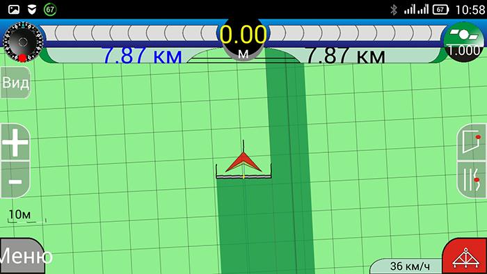
The processed part of the field is painted in a second color. Deviation from the correct course is visually visible on the screen, the operator mustalign the tractor in the right direction. Also, the speed of the tractor, the number of satellites, and the area of the cultivated field will be visible on the screen.
It is used on agricultural machinery to perform precise agricultural work on sowing and applying fertilizers and agrochemicals. And also for accurate measurement of the field area.
The course indicator will allow:
- to carry out work without gaps and covered when applying fertilized crops, spraying,
- work in difficult weather conditions, at night with insufficient visibility in the fog,
- reduces the cost of fertilizer, seed material and chemicals and the consumption of DT.
Characteristics:
Accuracy of measurements between rows is from 20 to 50 cm(//tractor-service.com)
Accuracy of area measurement up to 1 hundredth.
Work via Bluetooth wireless interface
Data refresh rate 5 Hz
External antenna:
- Antenna housing - durable plastic, degree of protection IP-65 (full protection against dust and rain)
-Magnetic fastening (a neodymium magnet provides
reliable fixation on metal surfaces, protective film
on the magnet prevents scratches)
- Supply voltage from 5 to 36 Volts
- The length of the power cable is 5 meters
- Overall dimensions: Ø153 × 100 mm
-Weight: 0.8 kg
-Working temperature: -30ºС + 70ºС
Warranty service - 1 hour
High-precisionparallel driving system GPS/GLONASS, this is a professional navigation equipment. The accuracy of the measurements during parallel driving is from 20 to 50 cm. When measuring the field area, it is from 1 hectare.
Ease of use:
The processed part of the field is painted in a second color. Deviation from the correct course is visually visible on the screen, the operator mustalign the tractor in the right direction. Also, the speed of the tractor, the number of satellites, and the area of the cultivated field will be visible on the screen.
It is used on agricultural machinery to perform precise agricultural work on sowing and applying fertilizers and agrochemicals. And also for accurate measurement of the field area.
The course indicator will allow:
- to carry out work without gaps and covered when applying fertilized crops, spraying,
- work in difficult weather conditions, at night with insufficient visibility in the fog,
- reduces the cost of fertilizer, seed material and chemicals and the consumption of DT.
Characteristics:
Accuracy of measurements between rows is from 20 to 50 cm(//tractor-service.com)
Accuracy of area measurement up to 1 hundredth.
Work via Bluetooth wireless interface
Data refresh rate 5 Hz
External antenna:
- Antenna housing - durable plastic, degree of protection IP-65 (full protection against dust and rain)
-Magnetic fastening (a neodymium magnet provides
reliable fixation on metal surfaces, protective film
on the magnet prevents scratches)
- Supply voltage from 5 to 36 Volts
- The length of the power cable is 5 meters
- Overall dimensions: Ø153 × 100 mm
-Weight: 0.8 kg
-Working temperature: -30ºС + 70ºС
Warranty service - 1 hour
|
Shop, contacts | |
Oleg / отзывы, инфо. / activity assessment | |
|
Phone:
+38 xxxxxx
show
| |
All user ads ~50 | |
Ad ID: #959878
(added by a registered user, registration date: 17-09-2019)
Added/Updated: 09-14-2026 10:20 (relevant, until: 09-14-2027)
Permanent ad address:
Showed / watched for today: ?, total: ?
Similar ads
Among them there are many interesting ones...
Filters: Parallel driving systems




All Ukraine: Agricultural equipment, inventory 45593 / Agricultural equipment, inventory 1552 / Systems of precision agriculture 113
Ternopil region: Agricultural equipment, equipment, inventory 267 / Agricultural equipment, inventory 15 / Systems of precision agriculture 2